
Minimum temperatures are for the night/early morning, maximum temperatures are for the daytime,
whilst precipitation amounts and probabilities are for the 24 hours from midnight.
Temperatures for the Melbourne observation site (at Olympic Park) are in brackets.
| Day & Date | Morning | Afternoon | Min Temp (deg C) | Max Temp (deg C) | Precip Amount (mm) | Precip Prob (%) | 9am Wind/ 3pm Wind Melb Apt (km/hr) |
|---|---|---|---|---|---|---|---|
| Mon-4-11-2024 | Cloudy. | Sunny. | 12.6 (12.2) | 20.7 (19.5) | 0 | 22 | SW 8 S 10 Gusts30 |
| Tue-5-11-2024 | Sunny. | Partly Cloudy. | 10.9 (10.4) | 27.2 (26.2) | 0 | 5 | NNE 8 NNE 15 Gusts35 |
| Wed-6-11-2024 | Possible Shower. | Possible Shower. | 19.8 (19.1) | 32 (31.4) | 0 | 47 | N 25 NW 25 Gusts60 |
| Thu-7-11-2024 | Shower. | Shower. | 15.3 (14.8) | 22.6 (21.4) | 0.7 | 54 | SW 10 S 15 Gusts40 |
| Fri-8-11-2024 | Cloudy. | Cloudy. | 12.8 (12.7) | 22.9 (21.8) | 0 | 36 | WNW 25 W 30 Gusts60 |
| Sat-9-11-2024 | Cloudy. | Sunny. | 12.3 (11.9) | 21.2 (20) | 0 | 34 | WSW 8 S 10 Gusts30 |
| Sun-10-11-2024 | Cloudy. | Sunny. | 12.3 (11.8) | 20.1 (18.7) | 0 | 23 | SSE 12 S 20 Gusts40 |
| Mon-11-11-2024 | Partly Cloudy. | Possible Shower. | 11.5 (10.8) | 25.5 (24.9) | 0 | 43 | NNE 20 NNE 25 Gusts55 |
| Tue-12-11-2024 | Shower. | Thunder. | 15.1 (14.4) | 24.1 (23.3) | 2.5 | 65 | N 15 NNE 20 Gusts50 |
| Wed-13-11-2024 | Shower. | Shower. | 14.4 (13.9) | 23.7 (22.5) | 2.9 | 59 | SW 10 S 15 Gusts40 |
| Thu-14-11-2024 | Shower. | Shower. | 13.3 (13.2) | 21.1 (20.1) | 2.3 | 69 | WNW 25 W 30 Gusts60 |
| Fri-15-11-2024 | Shower. | Shower. | 11.6 (11.7) | 19.6 (18.5) | 1.7 | 67 | WNW 25 W 30 Gusts60 |
| Sat-16-11-2024 | Partly Cloudy. | Cloudy. | 11.6 (11.5) | 21.6 (20.4) | 0 | 32 | WNW 25 W 30 Gusts60 |
| Sun-17-11-2024 | Cloudy. | Sunny. | 12.6 (12.2) | 21.8 (20.4) | 0 | 25 | SW 8 S 10 Gusts30 |
Acknowledgement: Bureau of Meteorology & World Meteorological Organisation
| Sunny | Dry | Haze | Mist | Fog | Partly Cloudy | Cloudy | Windy | Dust |
| Possible Shower | Drizzle | Shower | Snow | Rain | Thunder | Cyclone |
| Icon | Meaning |
|---|---|
| Sunny: | Sun shines >75% of the time |
| Dry: | As 'sunny', but used on days when Max > 30 Deg C & Relative Humidity drops below 10% |
| Haze: | As 'sunny', but used on days when visibility drops below 5000 m due to smoke |
| Mist: | Visibility below 5000 m due to water droplets but above 1000 m (also used on days when isolated fog patches) |
| Fog: | Visibility below 1000 m |
| Partly Cloudy: | Sun shines between 25% & 75% of the time |
| Cloudy: | Sun shines <25% of the time |
| Windy: | No precipitation & wind speed averages 'fresh' (18 kts) or stronger |
| Dust: | Visibility <1km due to dust raised by wind |
| Possible Shower: | Isolated light precipitation <25% of the metropolitan area |
| Drizzle: | Liquid precipitation that is almost continuous & made up of fine droplets |
| Shower: | Brief periods of liquid precipitation |
| Snow: | Snow or sleet falls (includes cases of flurries and/or ice) |
| Rain: | Liquid precipitation that is almost continuous but droplets are of medium size or large (not fine) |
| Thunder: | Thunder heard or lightning seen |
| Cyclone: | Wind speed averages 'storm force' (60 kts) or stronger |
Weather Pattern for Mon-4-11-2024:
High near South Australian coast.
Light to moderate westerly flow across Victoria.
Bay Forecast
10 to 15 knot W to SW wind.
Waves of 1 metre.
Melbourne Terminal Aerodrome Forecast (TAF)
TAF YMML 1212 VRB03KT CAVOK
FM21 34012KT 9999 FEW025
FM03 22012KT CAVOK
RMK
T 17 14 11 12 Q 1014 1014 1013 1014
THREE MONTH OUTLOOK FOR DEC/JAN/FEB: NCEP's Depiction of the Global Sea Surface Temperature Evolution The average Indian Ocean Dipole Mode Index for the past week is -0.93 (-1.79 standard deviations), the average Southern Oscillation Index (SOI) for the past 90 days is 2.2, the average SOI for the past 30 days (click here for a picture of recent trends) is 3.67, and the latest recorded bimonthly Multivariate ENSO Index (MEI) is -0.177. The expected MEI, adjusted by the Indian Ocean Dipole Mode Index and also by recent values of the SOI, for OCT/NOV is -0.99. Such a value of MEI indicates a sea surface temperature distribution that corresponds to a weak La Niña. This suggests: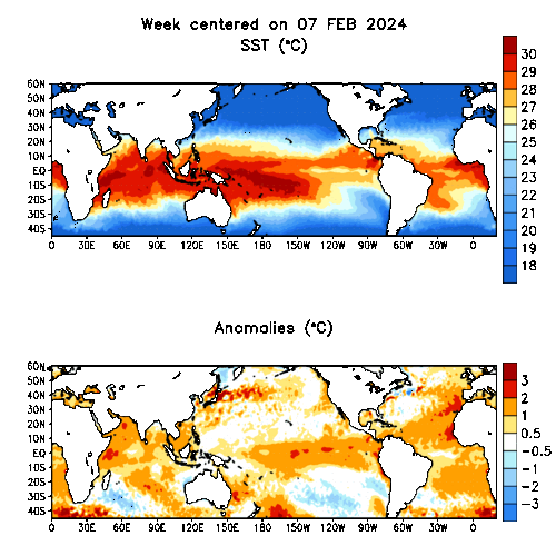
RAINFALL: There is a slightly enhanced chance that total DEC/JAN/FEB rainfall will be above normal in the NORTHERN COUNTRY, NORTHEAST and WEST GIPPSLAND Districts, there is a very slightly enhanced chance that rainfall will be above normal in the NORTH CENTRAL and EAST GIPPSLAND Districts, but there is little indication as to whether rainfall will be below, near or above normal in other Victorian Districts.
OVERNIGHT TEMPERATURES: There is a slightly enhanced chance that average DEC/JAN/FEB overnight temperatures will be below normal in the WIMMERA District, there is a very slightly enhanced chance that overnight temperatures will be above normal in the NORTH CENTRAL, EAST GIPPSLAND, WEST GIPPSLAND and CENTRAL Districts, but there is little indication as to whether overnight temperatures will be below, near or above normal in other Victorian Districts.
DAYTIME TEMPERATURES: There is a slightly enhanced chance that average DEC/JAN/FEB daytime temperatures will be below normal in the NORTHERN COUNTRY, NORTHEAST and WEST GIPPSLAND Districts, there is a very slightly enhanced chance that daytime temperatures will be above normal in the CENTRAL District, but there is little indication as to whether daytime temperatures will be below, near or above normal in other Victorian Districts.
30 DAY OUTLOOK FOR MELBOURNE:
Today's scientists talk in terms of the continent's large climate variability from season to season, and from year to year. What causes these fluctuations? They are, in part, connected with the climate phenomenon called the Southern Oscillation, a major air pressure shift between the Asian and east Pacific regions whose best-known extremes are El Niño events and La Niña events. The Pacific Ocean is a huge mass of water which controls many climate features in its region. Its equatorial expanse, far larger than the Indian or Atlantic Oceans, is critical to the development of the Southern Oscillation and the El Niño and the La Niña. The Multivariate ENSO (El Niño Southern Oscillation) Index, which combines the Sea Surface Temperature (SST) distribution across the Pacific with various features of the atmospheric circulation, is used to monitor the evolution of the El Niño and Southern Oscillation phenomena. The MEI is a bimonthly index which is calculated at the end of each month.
Another region of Sea Surface Temperature variability that impacts on Australian climate is that of the Indian Ocean. One mode of variability that appears to affect Australian rainfall, particularly the south east of the country, is the Indian Ocean Dipole (IOD). The IOD referred to here is defined by an index that is the difference between SST in the western (50°-70°E, 0°S-10°N) and eastern (90°-110°E, 10°-0°S) tropical Indian Oceans. A positive Indian Ocean Dipole Mode Index (DMI) occurs when the western basin is warmer than average and the eastern basin is cool and hence the DMI is positive. These regions were proposed in a paper by Saji et al. (1999) on the Indian Ocean Dipole that showed a modulation in Australian seasonal rainfall with DMI positive and negative years. The current Indian Ocean Dipole Mode Index (DMI) is -1.79 standard deviations.
Also impacting upon Australian climate variability is a phenomenon known as the Intra Seasonal Oscillation (ISO) (also known as the Madden-Julian Oscillation (MJO), after Madden and Julian, who first identified it in the early 1970s). They discovered that, at many locations in the tropics, surface pressure and upper atmospheric winds tend to go through a coherent cycle over periods of about 40 to 50 days. It has been found that a broad area of active cloud and rainfall propagates eastwards around the equator at intervals of between about 40 and 50 days. These are not strict time limits - research over the years has pushed the limits of the oscillation's period to between about 30 and 60 days. The Madden-Julian Oscillation (MJO) is presently operating in Phase 5. This is reflected in the near-equatorial enhanced convection being found over the over the eastern part of what is referred to as the Maritime Continent (Indonesia). Following Phase 5, the region of enhanced convection often moves from the eastern part of Indonesia to the western Pacific.
In Melbourne, at this time of the year, a combination of the MEI, the DMI, and the MJO Phase, such as what we have operating now, suggests, over the following 30 days:
RAINFALL: There is a 38% chance of it being wet, a 33% chance of normal rainfall, and a 29% chance of it being dry.
|
|
|
INPUT DATA
| Day & Date | MSLPmel | MSLPhay | MSLPsmi | MSLPgab | MSLPmtg | MSLPfor | 700 rhmel | 850 temp | min 9am 12noon 3pm 3pmdpt gfsprecip | syn type | offprecis climatology | prob TS | prob FOG | raw MIN | raw MAX | raw PoP | raw QPF |
|---|---|---|---|---|---|---|---|---|---|---|---|---|---|---|---|---|---|
| Initial | 1009.1 | 1010.1 | 1005.8 | 1006 | 1011.4 | 1015.4 | 30.7 | 8.4 | 18.5 19.9 20.2 21.9 7.3 | - | - | - | - | - | - | - | - |
| Mon-4-11-2024 | 1015.4 | 1015.2 | 1013 | 1014.4 | 1016.3 | 1013.6 | 38.7 | 1.8 | 0 | 8 | PARTLY CLOUDY 12-20 12.4-21.2 30% 0- 1 (19% 0) | 0.3% | 0.4% | 11.8 | 19.6 | 21.4% | 1.1 |
| Tue-5-11-2024 | 1015.7 | 1015.1 | 1015.9 | 1017.9 | 1014.7 | 1006.1 | 30 | 10.2 | 0 | 18 | SUNNY 10-27 10.5-28 5% 0- 0 (1% 0) | 2.5% | 3.9% | 10.5 | 26.2 | 5.8% | 5.8 |
| Wed-6-11-2024 | 1006.7 | 1009.5 | 1004.7 | 1010.4 | 1006.4 | 1014.2 | 77.3 | 17.6 | 0 | 21 | SHOWER OR TWO WINDY 19-33 19.7-33.6 60% 0- 4 (47% 1) | 8.6% | 0.5% | 20.8 | 27.4 | 50.9% | 3.9 |
| Thu-7-11-2024 | 1012.6 | 1012 | 1012 | 1011.7 | 1014 | 1020.1 | 30 | 7.9 | 0.1 | 9 | SHOWER OR TWO 14-21 14.5-22.2 50% 0- 2 (47% 1) | 5% | 0.1% | 14 | 21.8 | 48.4% | 4.1 |
| Fri-8-11-2024 | 1014.9 | 1017.1 | 1009.7 | 1011.9 | 1017.2 | 1021.3 | 30 | 3.4 | 0 | 39 | PARTLY CLOUDY 12-22 12.1-23.2 30% 0- 1 (25% 0) | 2.9% | 0.3% | 11.3 | 20.8 | 46.4% | 1.2 |
| Sat-9-11-2024 | 1019.7 | 1019.9 | 1017 | 1018.2 | 1020.4 | 1016.7 | 30 | 2.7 | 0 | 8 | POSSIBLE SHOWER 12-20 12.4-21.2 40% 0- 1 (47% 1) | 0.5% | 0.4% | 10.3 | 19.6 | 18% | 0.9 |
| Sun-10-11-2024 | 1025.2 | 1022.1 | 1026.2 | 1024.1 | 1026.2 | 1015.7 | 70 | 2.4 | 0 | 30 | CLOUDY 12-19 12.5-20.4 30% 0- 1 (28% 0 | 0.4% | 0.7% | 11.9 | 19 | 6.3% | 0.4 |
| Mon-11-11-2024 | 1020.4 | 1018.9 | 1024.9 | 1027.2 | 1019.4 | 1018 | 30 | 8.3 | 0.3 | 50 | Empty 12.3-22.5 39% 2 | 4.8% | 3.5% | 10 | 27.3 | 17.2% | 5.2 |
| Tue-12-11-2024 | 1014.7 | 1012.7 | 1016.1 | 1018.1 | 1013.7 | 1017.6 | 90 | 8.7 | 7.2 | 33 | Empty 12.3-22.5 39% 2 | 25.3% | 0.8% | 16.5 | 22.4 | 72% | 4.7 |
| Wed-13-11-2024 | 1009.5 | 1009.1 | 1007.8 | 1009.8 | 1012.3 | 1016.3 | 46 | 9.2 | 3.5 | 9 | Empty 12.3-22.5 39% 2 | 7.9% | 0.4% | 13.2 | 21.7 | 39.9% | 4 |
| Thu-14-11-2024 | 1006.4 | 1009.3 | 1001.8 | 1004.1 | 1009.2 | 1022.9 | 60.4 | 0.6 | 2.4 | 39 | Empty 12.3-22.5 39% 2 | 9.6% | 0.3% | 11.2 | 18.7 | 80.2% | 2.5 |
| Fri-15-11-2024 | 1006.2 | 1011.5 | 1001.5 | 1003.1 | 1012.6 | 1022.9 | 70.8 | -1.4 | 4.8 | 39 | Empty 12.3-22.5 39% 2 | 8.5% | 0.3% | 9.8 | 16.8 | 80.7% | 2.6 |
| Sat-16-11-2024 | 1017.1 | 1019.5 | 1010.8 | 1013.2 | 1019.7 | 1020.3 | 30 | 0.7 | 0 | 39 | Empty 12.3-22.5 39% 2 | 3.1% | 0.2% | 9.6 | 18.7 | 32.6% | 0.9 |
| Sun-17-11-2024 | 1022.7 | 1022.1 | 1021 | 1021.5 | 1024 | 1015.3 | 30 | 1.8 | 0 | 10 | Empty 12.3-22.5 39% 2 | 0.4% | 1.9% | 11.6 | 20.1 | 21.1% | 1.4 |
| Day 15 | 1018.9 | 1017.6 | 1017.8 | 1017.6 | 1020 | 1012.5 | 30 | 7.3 | 0 | ooo | ooo | ooo | ooo | ooo | ooo | ooo | ooo |